Google Maps - Updated?

For all your general chit chat, caching or not.
Laighside Legends
10000 or more caches found
Posts: 1304
Joined: 05 October 10 10:20 pm
Location: Australia

Google Maps - Updated?

Post by Laighside Legends » 11 November 10 9:40 am

Just noticed that Google have changed their map layout...

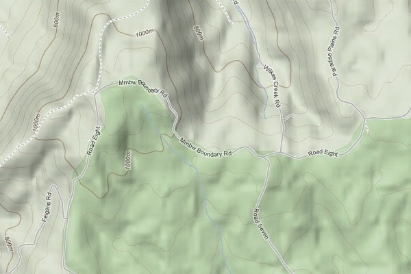
All sealed roads are now marked as major roads
All unsealed roads are no longer on the map unless you zoom right in and they then show up as a 4WD track. (I think 4WD track was the meaning of the dotted lines) :?: :?: :?:
Some 4WD tracks now show up as minor roads when you zoom in?
There are also darker patches on the map now??? (possibly built-up areas???)

Bit annoyed that unsealed roads don't show up any more as some where just as good as the sealed ones :(

User avatar
CraigRat
850 or more found!!!
Posts: 7015
Joined: 23 August 04 3:17 pm
Twitter: CraigRat
Facebook: http://facebook.com/CraigRat
Location: Launceston, TAS
Contact:

Re: Google Maps - Updated?

Post by CraigRat » 11 November 10 10:55 am

I don't see this on Google Maps

Do you mean in Google Earth?

Laighside Legends
10000 or more caches found
Posts: 1304
Joined: 05 October 10 10:20 pm
Location: Australia

Re: Google Maps - Updated?

Post by Laighside Legends » 11 November 10 11:05 am

No, Google Maps
http://maps.google.com.au/ (map view not satellite view)

Urban areas probably haven't changed much as they don't have unsealed roads

User avatar
Team Wibble
2100 or more geocaches found
Posts: 1054
Joined: 18 October 04 11:47 am
Location: Adelaide

Re: Google Maps - Updated?

Post by Team Wibble » 11 November 10 11:50 am

Laighside Legends wrote:No, Google Maps
http://maps.google.com.au/ (map view not satellite view)

Urban areas probably haven't changed much as they don't have unsealed roads
I had a quick look in a familiar area (Adelaide Hills where my parents live, plenty of unsealed roads about the place) and I can't see any difference - all the unsealed roads, even those that are really no more than a dead-end shared driveway, are still showing up as minor roads.

User avatar
Cached
2500 or more caches found
Posts: 3087
Joined: 24 March 04 4:32 pm
Location: Launceston, Tasmania
Contact:

Re: Google Maps - Updated?

Post by Cached » 11 November 10 11:53 am

I can't see any changes out where we are - although the northern expressway has made an appearance. Albeit a very thin one.

Laighside Legends
10000 or more caches found
Posts: 1304
Joined: 05 October 10 10:20 pm
Location: Australia

Re: Google Maps - Updated?

Post by Laighside Legends » 11 November 10 12:24 pm

Hmmm... :?
Maybe its not all unsealed roads...
Nearly all the ones on Yorke Peninsula are now marked as "4WD tracks"

The northern expressway isn't much and it doesn't quite go all the way! - there is a surveyed road near home that was never built and is now part of a paddock and even that gets a bigger mention!

Any ideas what those dark shaded areas mean??

User avatar
Cached
2500 or more caches found
Posts: 3087
Joined: 24 March 04 4:32 pm
Location: Launceston, Tasmania
Contact:

Re: Google Maps - Updated?

Post by Cached » 11 November 10 1:19 pm

Can you tell us where to find a "dark shaded area" to have a look at?

Laighside Legends
10000 or more caches found
Posts: 1304
Joined: 05 October 10 10:20 pm
Location: Australia

Re: Google Maps - Updated?

Post by Laighside Legends » 11 November 10 1:49 pm

How do you upload images to GCA to use in forum posts?
I sure I could find it but it may take me a while...

User avatar
Map Monkey
1050 or more caches found
Posts: 2214
Joined: 08 April 04 3:06 pm
Location: Banana Republic
Contact:

Re: Google Maps - Updated?

Post by Map Monkey » 11 November 10 2:04 pm

Just post the Link to the Google Map page ..... top right of the GM image for the link button. :wink:

mm

Philipp
1350 or more caches found
Posts: 591
Joined: 24 January 10 3:08 pm
Twitter: derfuzzel
Location: Melbourne, VIC
Contact:

Re: Google Maps - Updated?

Post by Philipp » 11 November 10 2:15 pm

Oh boy ... HUGE difference for the area I cached in last weekend. By chance I still got a screenshot from last Saturday:

This is the GMap link:
http://maps.google.com.au/maps?f=q&sour ... 2&t=p&z=14

and this is how it looked like a few days ago:

Image

Laighside Legends
10000 or more caches found
Posts: 1304
Joined: 05 October 10 10:20 pm
Location: Australia

Re: Google Maps - Updated?

Post by Laighside Legends » 11 November 10 2:25 pm

http://maps.google.com.au/maps?ie=UTF8& ... 14548&z=11
This shows the dark shaded areas - big one near Wauraltee, others at Minlaton and Black Point

http://maps.google.com.au/maps?ie=UTF8& ... 38409&z=15
This might help explain what I mean. When I say major road I mean the yellow ones, minor roads the white ones and 4WD tracks the dotted ones.
Except for in the town the dotted lines would be the best unsealed roads in the area and the white ones are on closed roads, nonexistent roads and 4WD(ish) tracks.

For future use, how do upload images to the forum? - Is there somewhere in the wiki that explains it?

RebornCyclist
1850 or more caches found
Posts: 116
Joined: 17 December 09 1:41 pm
Location: Kingborough

Re: Google Maps - Updated?

Post by RebornCyclist » 11 November 10 2:36 pm

Wow - I'm struggling to understand how they've come up with what they've done.
There's a reserve near where I live, with a network of fire trails.
Previously, they were all there as dotted lines.
Now, one of them is there as a solind whit line (minor road?), and the others are missing, at any zoom level!
I also looked at an area that I've been biking in, and one unselaed (but high quality) road has become a dotted line, and other nearby 4WD tracks have disappeared.
Looks like a step backwards to me...

Philipp
1350 or more caches found
Posts: 591
Joined: 24 January 10 3:08 pm
Twitter: derfuzzel
Location: Melbourne, VIC
Contact:

Re: Google Maps - Updated?

Post by Philipp » 11 November 10 3:00 pm

Laighside Legends wrote:For future use, how do upload images to the forum? - Is there somewhere in the wiki that explains it?
Hi there

here is an how-to:
http://forum.geocaching.com.au/viewtopi ... =2&t=14878

cheers

User avatar
rogerw3
8000 or more caches found
Posts: 683
Joined: 26 July 09 11:11 am
Location: Lithgow

Re: Google Maps - Updated?

Post by rogerw3 » 11 November 10 4:00 pm

:?:
Wow! This is weird, many of the tracks that used to be there are gone and now nonexistent roads are shown. The "roads" shown in the centre at right angle to each other are in fact cadastre boundaries, if you check out the contour it is obvious no straight road could be put there.

http://maps.google.com.au/maps?f=q&sour ... 2&t=p&z=15

mark_rattigan
800 or more hollow logs searched
Posts: 79
Joined: 22 March 08 5:55 pm
Twitter: m_ratt
Location: Harrison, ACT

Re: Google Maps - Updated?

Post by mark_rattigan » 11 November 10 4:54 pm

Google have been 'updating' maps apparently.

http://news.softpedia.com/news/Google-M ... 5948.shtml

Post Reply