You mean this one - http://www.waymarking.com/waymarks/WM338Xcaughtatwork wrote:Interestingly, this cache http://www.geocaching.com/seek/cache_de ... wp=GC13JXK sits below one of those black thingies but is not in the list. Is is a real one? A fake one? One not included for whatever reason.
TrigPointing
-
The Spindoctors

- Posts: 1767
- Joined: 08 October 03 8:00 pm
- Location: Sydney
- Contact:
-
Richary
- 8000 or more caches found

- Posts: 4189
- Joined: 04 February 04 10:55 pm
- Location: Waitara, Sydney
<p>I guess that also brings up the question of naming them (not knowing what is in the dataset you have). I would prefer a fixed prefix like TP Brown Mountain for example, so when it gets abbreviated in the GPS the TP (or whatever) will be maintained so we know what it is. <p>Rather than Brown Mountain Trig that would be abbreviated to BROWNM in my GPS. And without checking the data may not know if it is a trig or a cache.caughtatwork wrote:TP vs GA is a good one.
We can easily accommodate GA10000 up to GA99999 so that's not an issue. Having them as TP as said would mean they can be easily discernible as TP's.
-
caughtatwork

- Posts: 17016
- Joined: 17 May 04 12:11 pm
- Location: Melbourne
- Contact:
The dataset I have been given has these thingies marked as "Horizontal Control Point". Are they the same thing? I'm a little worried that we're creating a set of points that aren't what we think they are.
Good point on the names. Not all of the points in the file have a name, so we'd create something generic for those.
Good point on the names. Not all of the points in the file have a name, so we'd create something generic for those.
-
caughtatwork
- Posts: 17016
- Joined: 17 May 04 12:11 pm
- Location: Melbourne
- Contact:
Yeah, that's the one. It's not in the dataset I was given, so I'm not quite sure what dataset I have. There are around 5,000 points in the dataset, but I would expect more than that if it's all the trig points in Oz.Spindoc Bob wrote:You mean this one - http://www.waymarking.com/waymarks/WM338Xcaughtatwork wrote:Interestingly, this cache http://www.geocaching.com/seek/cache_de ... wp=GC13JXK sits below one of those black thingies but is not in the list. Is is a real one? A fake one? One not included for whatever reason.
-
caughtatwork
- Posts: 17016
- Joined: 17 May 04 12:11 pm
- Location: Melbourne
- Contact:
This is the dataset:
http://spreadsheets.google.com/ccc?key= ... Kk3XlP-jSQ
http://spreadsheets.google.com/ccc?key= ... Kk3XlP-jSQ
-
TeamGeoPlesk
- 1350 or more caches found

- Posts: 180
- Joined: 06 October 07 6:55 pm
- Location: Tumut
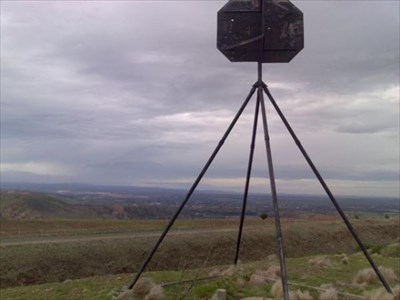
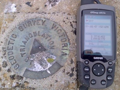
The data, to the best of my knowledge, describes trig points. The american equivilant (benchmarks) can be any number of different types of survey points. Trig points being the black triangular things atop mountains(see http://img.groundspeak.com/waymarking/d ... 86267e.jpg). Most trig points have a small disk below them which is generally known as a benchmark/survey point (see http://img.groundspeak.com/waymarking/d ... bb33cf.jpg). There are quite litterely tens of thousands in each state.caughtatwork wrote:By the way, WTF are they? TrigPoints? BenchMarks? SurveyPoints? What are they really?
I suppose that it is a good point to bring up in the forums... what would we be more likely to want to go and find? I personally would only really be interested in trig points... not so much survey points. Having done a quick search of survey points in eltham, vic... i have 6 within a kilometer of my house... now finding and logging these may realy detract from the credibility and point of the search. On the other hand, searching out trig points which are always atop hills (or highest points in a given area as shown in the previous posting... great piccy by the way), almost always offers great views and a great challenge.
Hope thats the sort of answer you were wanting c@w... if not please excuse the ramble
-
TeamGeoPlesk
- 1350 or more caches found
- Posts: 180
- Joined: 06 October 07 6:55 pm
- Location: Tumut
The data is from the Geoscience Australia 250K GIS dataset ( see http://www.ga.gov.au/ under free data downloads)caughtatwork wrote:This is the dataset:
http://spreadsheets.google.com/ccc?key= ... Kk3XlP-jSQ
This dataset is an amalgamation of a number of themed datasets available freely to the public. I am 99.9% sure that the data in ShonkyMaps comes from this datset.
In this dataset there is what are known as Horizontal Control Points. This is where the data comes from. As far as I am aware, these Hor. Control Points are Trig Points.
-
caughtatwork
- Posts: 17016
- Joined: 17 May 04 12:11 pm
- Location: Melbourne
- Contact:
AHhh, that makes more sense. With just the trigpoints rather than the survey marks, that would be significantly less.
So, we have a dataset. Can we get a state for each point? If we wanted to present them by state, this would be the easiest method.
So the question comes back to "how to we want to incorporate these into the site"?
So, we have a dataset. Can we get a state for each point? If we wanted to present them by state, this would be the easiest method.
So the question comes back to "how to we want to incorporate these into the site"?
-
Sons of Callum
- 200 or more found

- Posts: 67
- Joined: 29 June 07 10:10 pm
- Location: Benalla VIC
-
caughtatwork
- Posts: 17016
- Joined: 17 May 04 12:11 pm
- Location: Melbourne
- Contact:
-
Team Red Roo

- 5500 or more caches found

- Posts: 375
- Joined: 02 May 03 9:30 pm
- Location: Armadale WA
- Contact:
If the full dataset is available for Excel, it wouldn't be all that difficult export it to a Csv file and then to write up a macro to import it into Gsak.
Once that is done, you would have cache id's (a rule would need to be made) and you could also use the buit-in Gsak GetCountry and GetState functions to populate those fields.
Gsak has no elevation field, so that data would be lost unless it was written to a UserData field or perhaps the UserNotes field.
-
TeamGeoPlesk
- 1350 or more caches found
- Posts: 180
- Joined: 06 October 07 6:55 pm
- Location: Tumut
States can easily be incorporated, i will add this as a column tonight to the dataset. Easy geonerd stuffcaughtatwork wrote:There are ways and means around this, it's just if we're given a state it's much less work for ME
I'll also get a aussie map organised tonight for all peoples interested. Again... easy for a geonerd
As for the data, the nature of a 250k dataset implies that it is fairly coarse, thus why some points are missing (for example there is no point there for Mt Eccles). The ones with no name are most likely in the middle of no where in a region without a name. I can arrange for these to have names generated given their locations.
Another way we could implement this is instead of publishing all 5000 caches (which may be counter productive with many being in arid zones, which would not neccessarily be found... ever) the list could be published as a GPX and dolled up to look like a pq in GSAK and on the gps. Then as people find these points they can publish them online with a description, difficulty, etc, etc. That way it saves space and those points published could later be downloaded with their full descriptions. This way it prevents points being published which are not accessable.
Just an idea if you follow my doodgy logic. As for how to incorporate it, i will have a think today and get back tonight... in the mean time work beccons!
-
caughtatwork
- Posts: 17016
- Joined: 17 May 04 12:11 pm
- Location: Melbourne
- Contact:
TP codes and names can be relatively easily generated. If you can add the state for me that would be most beneficial. If you could also add a name, that would make life easier for me too as I wouldn't need to match it against the DB to get the locale.
Personally I would like to see the whole dataset added to GCA so they are easily searchable by the online tools at GCA. e.g. my query, Google Maps, etc.
Having 5,000 points that people may not want to "ever" see could be a challenge. People may need to get used to using the My Query functions to see just what they want rather than the cuirrtent position of get "everything" for the state. This would be a problem longer term anyway.
So at the moment I have teh following requirements:
New cache type of TrigPoint
TPnnnn as the waypoint ID.
Name to have TP or Trig as the prefix (e.g. Trig Mount Atkinson)
Difficulty defaulted to 2 with added functionality for the finders to change the difficulty when they log it.
Terrain defaulted to 3 (right in the middle of the range) with added functionality for the finders to change the terrain when they log it.
New TrigPoints can be added as they are discovered.
TrigPoints are dealt with in the same way as a standard GCA cache and will be included in all stats as another cache type.
Short / Long descriptions on the TrigPoint page to be a standard default (if someone could write this it would be most appreciated). Maybe allow the description to be updated or maybe just let the logs tell the tales?
-
TeamGeoPlesk
- 1350 or more caches found
- Posts: 180
- Joined: 06 October 07 6:55 pm
- Location: Tumut
