Discussion about software such as GSAK, OziExplorer etc, as well as all things hardware, GPSrs, laptops, PDAs, paperless caching, cables etc
-
Map Monkey
- 1050 or more caches found

- Posts: 2214
- Joined: 08 April 04 3:06 pm
- Location: Banana Republic
-
Contact:
Post
by Map Monkey » 20 October 08 8:47 pm
I have the TopoPLUS Australia already, so i could supply one half of the deal.

If you have a tile done already we could compare.....

mm
-
Dooghan
- Posts: 671
- Joined: 06 April 03 5:03 pm
- Location: Launceston TAS
Post
by Dooghan » 20 October 08 11:56 pm
Why not compare it against GPS shots in my above post. Coordinates and zoom levels are in the shots

The 60CSx detail level was set to normal for the shots.
Dooghan
-
Map Monkey
- 1050 or more caches found
- Posts: 2214
- Joined: 08 April 04 3:06 pm
- Location: Banana Republic
-
Contact:
Post
by Map Monkey » 21 October 08 12:29 am
Dooghan wrote:Why not compare it against GPS shots in my above post. Coordinates and zoom levels are in the shots
The 60CSx detail level was set to normal for the shots.
Dooghan
Darn, i should have looked at those images a little closer.

mm
-
Map Monkey
- 1050 or more caches found
- Posts: 2214
- Joined: 08 April 04 3:06 pm
- Location: Banana Republic
-
Contact:
Post
by Map Monkey » 21 October 08 1:13 am
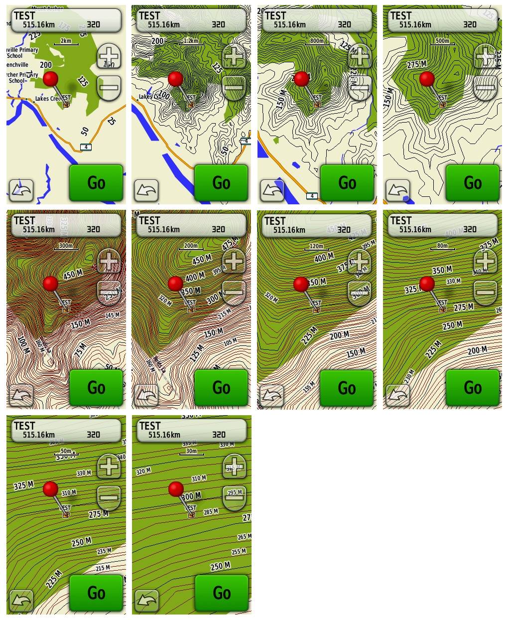
Well it looks like the 5m dataset might be rather nice for the price when it is finished.
A comparison of similiar areas (albeit with different GPSr's) shows that the CA 5m layers might be more pleasing in various areas, especially at 120m:
Contours Australia V? - 5m
 GPS TopoPLUS Australia 5m (including CN9 for clarity):
mm
-
Dooghan
- Posts: 671
- Joined: 06 April 03 5:03 pm
- Location: Launceston TAS
Post
by Dooghan » 21 October 08 5:55 am
Wow, that's interesting MM. It looks like the SRTM data to me. It looks like I've got mine a bit more smoother. The zoom levels are also interesting. I see that the 5m layer starts at the 300m and below on your GPS. Setting your GPS to "Most" should push it out to the 1.2km zoom which would make it next to impossible to read. Mine start at the 120m and below and setting the GPS to "Most" would push it out to the 300m zoom. I'll have to send you a test map to see if it is something to do with that model GPS or not. It looks like they have only used 25m and 5m layer to make the maps. Where I've used 100m, 50m, 10m and 5m layers. Interesting.
Dooghan
-
Map Monkey
- 1050 or more caches found
- Posts: 2214
- Joined: 08 April 04 3:06 pm
- Location: Banana Republic
-
Contact:
Post
by Map Monkey » 21 October 08 9:28 am
Yes, it is interesting.
I was talking to an employee and they mentioned that they had withheld releasing it a couple months ago because they "weren't happy" with the product just yet.

Hmmm, 1.2km at most detail (which is the setting i normally run my GPSr) looks terrible IMO:
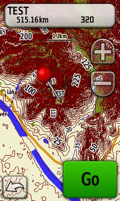
I'll have a look at your test map and see if the quality is consistant over the whole tile.
At this stage, your 5m dataset should win hands down.
mm
-
Dooghan
- Posts: 671
- Joined: 06 April 03 5:03 pm
- Location: Launceston TAS
Post
by Dooghan » 21 October 08 8:47 pm
Map Monkey wrote:Yes, it is interesting.
I was talking to an employee and they mentioned that they had withheld releasing it a couple months ago because they "weren't happy" with the product just yet.
I wonder if me releasing my free 10m set hurry them up a bit
Map Monkey wrote:Hmmm, 1.2km at most detail (which is the setting i normally run my GPSr) looks terrible IMO:
I'll have a look at your test map and see if the quality is consistant over the whole tile.
At this stage, your 5m dataset should win hands down.
mm
I figured it would look good. I also run all my GPS's on the "Most" detail. When I made the first version of CA I made it to run and view on the "Most" detail setting. That is when I found out how many people still use the "Normal" detail setting. I got a lot of messages about it and had to make the next and all versions after, set to the "Normal" detail level. Newbies

I am open to suggestions. Nothing is set in stone just yet. I'm just creating the contour data/base data that I need at the moment. I do have a global config file which will be used to make all the maps. It can still be changed.
Dooghan