Recently we were contacted about updating the LGA's in NSW. There have been changes to a number of LGA's including mergers, separations and other boundary adjustments. We found that the NSW Government offer access to spatial data that until recently has been very difficult to obtain and the main reason why some of the LGAs have become obsolete.
The data (if you're interested) can be found here https://portal.spatial.nsw.gov.au/porta ... b81e42433a
Some time in the next week or so (as time permits) we will be installing the new LGA zones and removing the old LGA zones. This should result in a better match for any LGA challenges that may apply for NSW. Note that the dragonZones which were based on the original LGAs will not be changing. They will continue to diverge from the LGAs as LGAs change.
We will be removing the following zones:
Armidale Dumaresq (A)
Ashfield (A)
Auburn (A)
Bankstown (C)
Boorowa (A)
Botany Bay (C)
Canterbury (C)
Conargo (A)
Cootamundra (A)
Deniliquin (A)
Gloucester (A)
Gosford (C)
Great Lakes (A)
Greater Taree (C)
Gundagai (A)
Guyra (A)
Harden (A)
Holroyd (C)
Hurstville (C)
Jerilderie (A)
Kogarah (C)
Leichhardt (A)
Manly (A)
Marrickville (A)
Murray (A)
Palerang (A)
Parramatta (C)
Pittwater (A)
Queanbeyan (C)
Rockdale (C)
Wakool (A)
Warringah (A)
Wellington (A)
Wyong (A)
Young (A)
We will be adding the following zones:
Armidale Regional Council
Bayside
Canterbury-Bankstown
Central Coast
Cootamundra-Gundagai
Cumberland
Edward River
Georges River
Hilltops
Inner West
MidCoast Council
Murray River
Northern Beaches
City of Parramatta
Queanbeyan-Palerang
We will have one more LGA that the NSW government recognise due to unincorporated areas of Norfolk Island and Far West Region which surrounds Broken Hill. I'm not sure whether they are considered LGA's for some challenges, but they are combined into a single zone for GCA LGA purposes.
If you believe that the data we are about to change is not right, please let us know and we'll try and work out why we have a difference.
Update of NSW Local Government Areas
-
caughtatwork

- Posts: 17017
- Joined: 17 May 04 12:11 pm
- Location: Melbourne
- Contact:
-
caughtatwork
- Posts: 17017
- Joined: 17 May 04 12:11 pm
- Location: Melbourne
- Contact:
Re: Update of NSW Local Government Areas
The LGA zones have been updated. The old ones have been marked as Disabled, but they may show up somewhere if I've made a coding error. If you notice one, please let me know.
-
Laighside Legends
- 10000 or more caches found

- Posts: 1304
- Joined: 05 October 10 10:20 pm
- Location: Australia
Re: Update of NSW Local Government Areas
It looks like Jerilderie seems to have ended up without an LGA ? No LGA shows up there on the GCA google maps. Also shows as unfound (or missing?) in my stats even though I've found 4 caches there.
-
caughtatwork
- Posts: 17017
- Joined: 17 May 04 12:11 pm
- Location: Melbourne
- Contact:
Re: Update of NSW Local Government Areas
Thanks.
It looks like Jerilderi and Murrumbidgee are now one large LGA called Murrumbidgee. I'll get an update later this afternoon.
We do know that some of the new LGA's don't fit perfectly with the existing LGA's, as they are from different sources. We get overlaps We're also looking into refreshing NSW as a whole to address this, BUT !!!! This will also likely affect the Victorian border as the two sources have different edges for the Murray River. Sigh.
It looks like Jerilderi and Murrumbidgee are now one large LGA called Murrumbidgee. I'll get an update later this afternoon.
We do know that some of the new LGA's don't fit perfectly with the existing LGA's, as they are from different sources. We get overlaps
-
Laighside Legends
- 10000 or more caches found
- Posts: 1304
- Joined: 05 October 10 10:20 pm
- Location: Australia
Re: Update of NSW Local Government Areas
Have you considered using the LGA data from OSM? It covers all of Australia, has consistent borders and I think it's up to date with the boundary changes to.
-
caughtatwork
- Posts: 17017
- Joined: 17 May 04 12:11 pm
- Location: Melbourne
- Contact:
Re: Update of NSW Local Government Areas
Could you point to the source? We're open to using anything we can that is free and open.
-
mattyrx

- 850 or more found!!!

- Posts: 265
- Joined: 21 May 10 9:57 pm
- Location: The Channon, NSW
- Contact:
Re: Update of NSW Local Government Areas
Looks like we can get Aussie-wide LGA data from the ABS too:
https://www.abs.gov.au/statistics/stand ... dary-files
They provide a shape file, which imports into Google Earth. You can then select individual LGAs and export a KML from there. Or export the whole thing as a KML. I can confirm that when importing NSW LGAs the borders don't line up exactly with the data we have now - including with other state LGAs (i.e. Murray River) - but have a few ideas to bring up at the next dev catchup that might work at fixing things.
-
Laighside Legends
- 10000 or more caches found
- Posts: 1304
- Joined: 05 October 10 10:20 pm
- Location: Australia
Re: Update of NSW Local Government Areas
I've used this site before with success despite the clunky interface https://osm-boundaries.com/caughtatwork wrote: ↑09 October 23 1:21 pmCould you point to the source? We're open to using anything we can that is free and open.
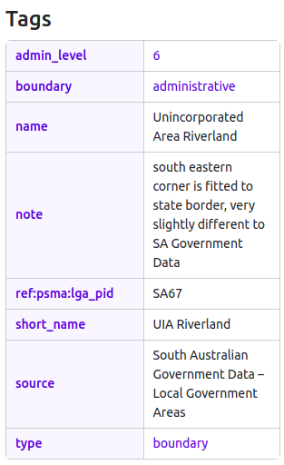
Looks like you want the level "6" boundaries to get LGAs in Australia
-
caughtatwork
- Posts: 17017
- Joined: 17 May 04 12:11 pm
- Location: Melbourne
- Contact:
Re: Update of NSW Local Government Areas
Thanks for that. There is inconsistency (as there always is) between different maps and details.
e.g. Ku-ring-gai in OSM "owns" the land near the Roseville Bridge, but other data from the ABS and Google Maps says that land is actually "owned" by Northern Beaches. It appears that there may be a discrepancy between mapping of the high water mark. There are other small sections of Ku-ring-gai which are also Northern Beaches and they are on the high water mark on the Ku-ring-gai side.
We will never be consistent within the various datasets, so we'll see what we can get and use that.
-
Laighside Legends
- 10000 or more caches found
- Posts: 1304
- Joined: 05 October 10 10:20 pm
- Location: Australia
Re: Update of NSW Local Government Areas
I think the folks at OSM have tried to fix most of those inconsistencies. Sometimes they even leave notes about it 
ProjectGC uses OSM data (I just realised they created that download site)
https://project-gc.com/Home/FAQ#3060278055
ProjectGC uses OSM data (I just realised they created that download site)
https://project-gc.com/Home/FAQ#3060278055
-
caughtatwork
- Posts: 17017
- Joined: 17 May 04 12:11 pm
- Location: Melbourne
- Contact:
Re: Update of NSW Local Government Areas
Nice, thanks. Good to know that is the case. We might seek to align ourselves to that data to minimise inconsistencies between sites planning LGA's.
-
caughtatwork
- Posts: 17017
- Joined: 17 May 04 12:11 pm
- Location: Melbourne
- Contact:
Re: Update of NSW Local Government Areas
Hmmm, can't find Mount Buller Alpine Resort. It's blank in the OSM data and the ABS data is not the same shape. I might have to just cut that shape from Mansfield and call it Buller.
-
Laighside Legends
- 10000 or more caches found
- Posts: 1304
- Joined: 05 October 10 10:20 pm
- Location: Australia
Re: Update of NSW Local Government Areas
It looks like they've got Falls Creek, Mt Hotham, Mt Baw Baw and Lake Mountain but are missing Mt Buller and Mt Stirling.
Those two are both in that "gap" inside Mansfield. Maybe the OSM people couldn't find a boundary between the two and decided it was too hard?
French Island is also missing. But they have Gabo Island. Go figure.
I think ProjectGC joins all of them together and calls it "Unincorporated Victoria"?
Those two are both in that "gap" inside Mansfield. Maybe the OSM people couldn't find a boundary between the two and decided it was too hard?
French Island is also missing. But they have Gabo Island. Go figure.
I think ProjectGC joins all of them together and calls it "Unincorporated Victoria"?
-
caughtatwork
- Posts: 17017
- Joined: 17 May 04 12:11 pm
- Location: Melbourne
- Contact:
Re: Update of NSW Local Government Areas
We have Mount Buller which covers Mount Stirling as the "missing piece" from Mansfield.
French Island is an L9
ACT is an L4
Various islands are L4
Lord Howe Island is an L9
Huon Valley (Tasmania) also covers Macquarie Island which seems very weird, so we'll spilt those.
Yulara and Ayers Rock Airport is an L9
There's also a weird rectangle just west of Maralinga which seems to be totally missing. Secret Government Business
Unincorporated Victoria is a ABS region that covers all other areas, consisting of small islands or ski resorts, which are administered either by the state government or management boards. Our current LGA's lump them together. The OSM data has them separate. I like separate now that we can.
-
Laighside Legends
- 10000 or more caches found
- Posts: 1304
- Joined: 05 October 10 10:20 pm
- Location: Australia
Re: Update of NSW Local Government Areas
How are you going to separate Mount Buller and Mount Stirling from each other? It seems like OSM can't even work out the answer to that.
The Maralinga township used to be excluded from the Maralinga LGA (it was part of Unincorporated SA) but apparently that changed a few years ago and now it is part of Maralinga LGA. But that bit that got left behind is very weird. It's just not part of anything.
The Maralinga township used to be excluded from the Maralinga LGA (it was part of Unincorporated SA) but apparently that changed a few years ago and now it is part of Maralinga LGA. But that bit that got left behind is very weird. It's just not part of anything.