If it's in GSAK, right-click to view in browser (offline) gives you the best of both worlds: you keep all of GSAK's filtering etc. on the spot and you also get a human-readable format for the cache.Mix76 wrote:Which is an interesting (to me) question , if your happy to cart your laptop around is the cache info in the gpx format usable or is it more readable after you spin/pluk/html it.
Does more technology lessen the fun?
-
Papa Bear_Left

- 800 or more hollow logs searched

- Posts: 2573
- Joined: 03 April 03 12:28 am
- Location: Kalamunda, WA
- Contact:
-
riblit

- It's the journey.

- Posts: 3444
- Joined: 04 April 03 6:30 pm
- Location: Land Grant of John Campbell
I seem to remember mix76 saying something about running a MAC 'cause he couldn't find a real computer. Makes life a little interesting for him.Bear_Left wrote:If it's in GSAK, right-click to view in browser (offline) gives you the best of both worlds: you keep all of GSAK's filtering etc. on the spot and you also get a human-readable format for the cache.Mix76 wrote:Which is an interesting (to me) question , if your happy to cart your laptop around is the cache info in the gpx format usable or is it more readable after you spin/pluk/html it.
-
hedberg
- 300 or more found

- Posts: 20
- Joined: 04 April 04 1:32 pm
- Location: Göteborg, Sweden
- Contact:
Hey, what's this? Mac is real computers, I would prefer any Mac instead of the damn PC we have. Mac has at least a standard to follow, and less MicroSoft involvedriblit wrote:I seem to remember mix76 saying something about running a MAC 'cause he couldn't find a real computer. Makes life a little interesting for him.
Thanks for all your thoughts.
Last edited by Mix on 07 April 04 8:36 pm, edited 1 time in total.
-
riblit
- It's the journey.
- Posts: 3444
- Joined: 04 April 03 6:30 pm
- Location: Land Grant of John Campbell
Light Line, small hook, not much bait needed...hedberg wrote:Hey, what's this? Mac is real computers, I would prefer any Mac instead of the damn PC we have. Mac has at least a standard to follow, and less MicroSoft involvedriblit wrote:I seem to remember mix76 saying something about running a MAC 'cause he couldn't find a real computer. Makes life a little interesting for him.
-
The Ginger Loon

- 450 or more roots tripped over

- Posts: 824
- Joined: 28 March 03 9:09 pm
- Location: Tamworth
- Contact:

Ozi, Lap & Nads.
Special thanks to Nads - Thats actually Geo-Nads for coming around the other afternoon and helping me set up Ozi with the moving map feature. After hearing what Dooghans been up to in Qld with his Ozi I though I'd give it a try. Tell you what I'm not sorry. Being the gageteer I fell for it hook line and sinker when it came online so to speak.
I'm not sure if I'd actually use it to cache as I like to just put the co-ords in and go. There arn't enough new ones around here to simply go straight too and find, hence I like the cache where you have to think a little.
City caching it would be awesome. It would be a case of: "Next - ...and thank you very much: NEXT - ... and thank you very much: NEXT - ... and thank you very much."
I sat the laptop on my lap of all places to and from Orange (from Dubbo) the other day. About an hour and a half each way. I could name Creeks, Hills, Cliffs, small towns, streets before we got to them and find all the towns facilities if we needed to stop. It's like a crystal ball having Ozi and the right maps. I had a palm and the wife has apparently accidently sold it. That's alright - I'll get another one. The next one will have a cradle.
To answer your question - Technology could make it easier but it also make it more professional as well. It's not going to help once you've arrived so I guess which aspect you enjoy the most. For me I enjoy getting lost on the way and then finding the right way. I don't really enjoy the search so much unless it's on the top of a beautiful lookout like "Split Rock". That way after the search I can relax and enjoy the location.
My 2 cents.
The Bronze.
Red Ochre Cacher
Last edited by Bronze on 09 April 04 10:22 am, edited 1 time in total.
-
Team Geo-Nads
- 550 or more Caches found

- Posts: 53
- Joined: 05 April 03 10:08 am
- Location: Dubbo
- Contact:
Some Pics
Some pics from the other day. Workin well and about to seek out another cache with it this morning.
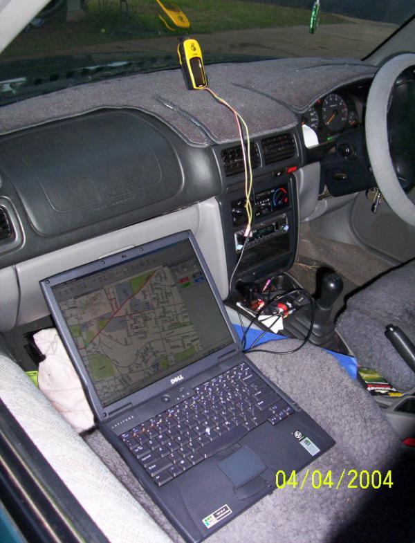
eTrex on the dash going into the com1(serial) port on the back of the laptop. Open Ozi with stateview in the CD drive, click on "Moving Map" and hey presto. Well not exactly but its working.
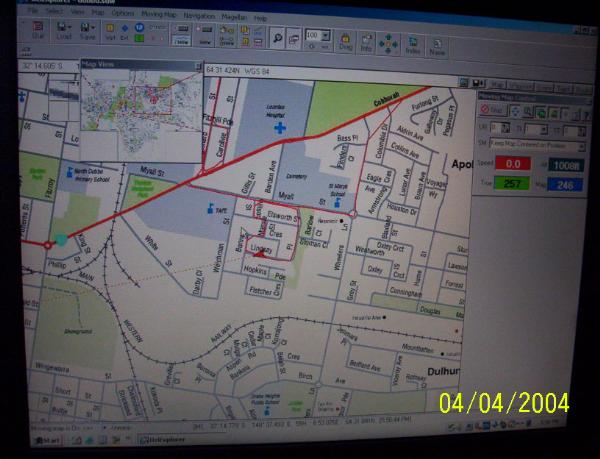
I also have the 250k series in the hard drive. In town it defaults to street maps, out of town it defaults to road maps and where these don't cover it should default to the 250k series.
Haven't worked out how to set co-ordinated to 'goto' with it yet. That's this mornings experiment, that and the new Coopers A/T's gracing the forester.
The Bronze.
Red Ochre Cache Technology Tinkerer.
eTrex on the dash going into the com1(serial) port on the back of the laptop. Open Ozi with stateview in the CD drive, click on "Moving Map" and hey presto. Well not exactly but its working.
I also have the 250k series in the hard drive. In town it defaults to street maps, out of town it defaults to road maps and where these don't cover it should default to the 250k series.
Haven't worked out how to set co-ordinated to 'goto' with it yet. That's this mornings experiment, that and the new Coopers A/T's gracing the forester.
The Bronze.
Red Ochre Cache Technology Tinkerer.
Bronze, You Know that HSIE's lease on that laptop runs out in September don't get too attached unless the HT buys it at end of lease its gooooone! And if the lady in B6 finds out that you put all those maps on it and then drove around the country with it look out. <br>
Ahh.. Nothing like a post only one person understands.
Ahh.. Nothing like a post only one person understands.
Ahem - I will have you know:
I have a professional responsibility to myself, my peers and more importantly my students to be up with the latest spatial, referencing datalogging and organisational technology systems. This has the potential to make HSIE, as a mandatory subject interesting - obviously not a goal in your classroom but regardless I owe it to all those little darlings who may just throw there had up one days to ask:
"Excuse me Sir, Is it possible to set a Latitude and Longitude waypoint into a portable computer such as a conventional laptop and have Global Positioning Systems technology coupled to an intuitive mapping software protocol to guide you to an unknown ground zero using an exisiting mapping datum which is replicated as a digitial raster or vector format media displayed in a varied range of scales and formats such as topo, photo, civil and state survey and sat representations of the Earths surface."
Well now I can say yes to such a question and move on with the lesson virtually undisturbed by one individual with a burning desire to know more. Had it been this time last year I could have lost the best part of the lesson discussing and considering the enquiry at length and truly not knowing the answer putting the the other 29 students into a frenzy of boredom.
The lady in B6 is being happily sustained with gifts of Easter eggs has full knowledge that after 4 months without it I need to catch up. If the HT dosen't buy out the lease then it's up for grabs and I can either put my hand up for it or argue that we need another as it was invaluable to my professional development (as above) and organisational requirements as a practicing social scientist. It is being used which is why it was leased in the first place. Be a different story if it sat in a draw like the first half of last year.
The Bronze.